For 2006 course onward
updated June 23, 2011
At the suggestion of OD, the one-eyed guy who has a stride that looks like he’s hopping over newts, I recently wrote a detailed description of the Western States Endurance Run course (beginning in 2006). If you’ve never run the race this might help you visualize the course. It is difficult to remember aid station to aid station, so a section by section account is what I’ve done.
- High Country – start to Robinson Flat
- New Trail – Robinson to Dusty
- The Canyons – Dusty to Foresthill
- Cal St – Foresthill to River
- Finish – River to Auburn

High Country – start to Robinson Flat (29.7 miles)
Uphill for the first hour. Lots of walking. Only people who think there is a bank, sub 17 hour runners, and those who like to drop before or at the river run all of this first hour. After topping out there is a lot of downhill, some of it steep. Lots of stream crossings and gentle uphills. Great views. I try not to think about what place I’m in. Eat. Don’t get hungry. Relaxed running. Red Star Ridge is exposed and could have lots of snow. The heat will get turned on. Duncan Canyon has long gentle grades. Lots of burned trees so the sun will be on us! The climb to Robinson is not that steep but it takes a bit of time. Be patient. Your crew and tons of people await. Eat significant food (beans or sandwich for me) at Robinson.
French Meadows 2010 Snow Route: In 2010, a newer alternate snow route was used which bypassed Lyons Ridge and Red Star Ridge aid stations. This took us down to a lower elevation and ran along French Meadows Reservoir on double track, gravel and paved roads, and some beautiful single-track on the Poppy Trail. A brand new short trail which hadn’t seen much traffic took us back up to the Duncan Canyon aid station and rejoined the normal course at mile 23.8.
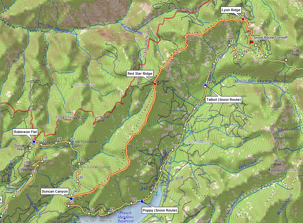
French Meadows 2011 Snow Route: In 2011, because the road to Robinson Flat didn’t get plowed in time for the race, the same route used in 2010 will be followed down to Duncan Canyon. From there, we’ll follow some paved road, dirt road, and trail to very close to the Millers Defeat Aid Station. If we continued on the regular course from there we’d not have enough mileage so a short out and back towards Robinson Flat will be done. Once we get back to Millers Defeat we will follow the regular route.

New Trail – Robinson Flat to Dusty Corners (38.0 miles)
The trail from Robinson Flat to Dusty is on some brand new single track and some existing single-track that the horses have used for several years.
The Little Bald Mtn trail is a 4 mile trail that starts and ends at Robinson Flat. In 2002-2005 we went clockwise on this fairly new (4 year old) trail for 3 miles and then headed straight for Duncan Peak rd and down the road to the Little Bald Mtn aid station.
With the new course we take the Little Bald Mtn trail counter-clockwise uphill for 1 mile. This will be a great opportunity to eat/drink after leaving Robinson, unlike the previous years. Since this is north facing it is likely to have snow. After a mile we rejoin the section we’ve run from 2002-2005 but are going the other direction. The new trail is off to the right after a short ways (1/4-1/2 mile?).
The new trail is downhill with some switchbacks through open/burned out area. This south facing trail is exposed. It is easy going to Miller’s Defeat aid station which is on road N43. After Miller’s Defeat it is relatively easy terrain – mostly flat and downhill – until a steep downhill to Dusty Corners. There is no substantial uphill at all and you can run the whole thing. This has been used by the horses for several years and is a fairly well established trail. Not really single track in the Waldo sense of the word, but not a road.
This new route is 8.3 miles from Robinson whereas the old route down Cavanaugh Ridge was 13.4 miles.
The Canyons – Dusty Corners to Foresthill (62.0 miles)
The Canyons are the next section. Some, including me my first year, think of them as ending at Michigan Bluff. I think that is a mistake. Volcano Canyon is hot and real and shouldn’t be overlooked. This section is probably the most feared section of the race, and it can destroy you mentally and physically, but the racing really begins *after* the canyons. You can make up time on the downs, but I wouldn’t suggest going hard on the ups. If you really want to be competitive in the race you need to survive the canyons so you can run after them.
Leaving Dusty Corners (mile 38) you are on a gravel road for a couple of 100 yards before turning right onto the Pucker Point Trail. This trail is new to us as of 2002. The horses had been using it already. It is generally gentle downhill and flattish all the way to Last Chance. There are some open exposed areas where you will feel the sun, but there is a lot of shade, too. The reason for the name is that there is an awesome view of Screwauger Canyon off to the right. Great place to stop on a training run, but on race day just a quick glance will have to do. After a few easy miles you rejoin the gravel road and run easy terrain (with some short downs) to Last Chance Aid Station.
Last Chance is the dropping point into Deadwood Canyon (north fork of the middle fork of the American River). It is steep downhill to the swinging bridge. Lots of oak leaves covering the trail. Let ‘er rip if your quads can handle it. Once you cross the bridge at the bottom you soon come to a creek that is a must stop for dousing. It is also good to drink. There is no aid at the bottom of this canyon. Devil’s Thumb is next. A little less than 2 miles steep up and probably about 34-40 minutes up on race day. Jim King and Brian Purcell supposedly have run all of this on race day. Bili and I run it in training just for fun – I will not be doing that on race day!
From Devil’s Thumb to El Dorado Creek is 5 miles of some of the best downhill running on the course. After running along Deadwood Ridge for a mile or two, you pass the pump and the cemetery and drop into the canyon. Great views. The halfway point of the course is at Kaput Spring a.k.a. The Pipe. There is aid at the bottom of El Dorado. There are a couple of short flat/ups on this descent so don’t be discouraged, just cruise over them.
The climb to Michigan Bluff is not as steep as DT but it is longer. Probably take you between 42-50 minutes to climb on race day. The first part of the climb is steep so eat whatever you grabbed at the aid station so you can run the easier sections up higher. There is alot of shade on this climb as well, with more exposed sections up higher.
Michigan Bluff is loud and exciting. This is the only place I plan on sitting down. I refuel and get my quads ice massaged. After MB you are on a road with flats and some ups and downs and a longish uphill section after turning right onto Chicken Hawk road. It is one of those hills that you can either run or walk and will probably do both.
Eventually you turn left back onto trail and begin the descent into Volcano. Easy, gentle downhill at first. This turns to rocky, technical, hot descent to Volcano Creek. [In 2007 a lot of the rocks were taken out so it is now much smoother] Cross the creek, dousing of course, and then you begin up. This is walkable at first and then it becomes gentle and flat until it gets steep and rocky right before Bath Rd. This has been the hottest place on the whole course for me. An aid station is at the start of the pavement. Bath Rd is less than a mile of gentle uphill on pavement and about 1.5 miles to Foresthill Aid Station.
The toughest terrain is over. The racing is about to begin.
Cal St – to the River (78.0)
Note: I use the old names Cal 1, Cal 2, Cal 3 for the aid stations on this section. Greg Soderlund, RD, has reminded me that the names were changed several years ago. The modern names are Dardenelles, Peachstone, and Fords Bar.
The trail from Foresthill to the river is known as Cal St or the Cal Loop. Pre 1986, the course followed paved and gravel roads through Todd Valley and White Oak Flat. While it wasn’t trail, it was a fairly direct route down to the river. In 1986 Cal St replaced the old Todd Valley route. For veterans it seemed to take forever to get to the river via the new single-track trail compared to the old route. For all of us, it ain’t no big deal because we never ran on the old route (well, I did on a training run once…). But I will tell you that it isn’t the most direct route down to the river so prepare for about a 3 hour tour (OD likes to take 4-5 hours and soak up all the scenery, Ticer likes to dislocate his finger and still run 2:39!).
So why give a 16 mile section a description when the canyons section was 24 miles long? Well, it is probably the crux of the race. This is where the top runners emerge and the others fall way back. Ask most of the top ten veterans and they’ll agree that this is where the racing begins. If you’ve got legs, the terrain from here to the finish is easy. If you don’t, you’ll be wondering where the hell the river crossing is and you will get passed. Strap in.
After leaving the aid station and the school, you’ll run downhill on Main St with your pacer (and others if you want). Foresthill is loud and more crowded than Michigan Bluff. When you turn left on Cal St and get on the single track trail the noise goes away. It gets remote very quickly. The first part of Cal St is some great downhill. A little rocky and technical so you want quads, agility and no blisters. It is a quick 30 minutes or so with only a few short ups down to Cal 1 (Dardenelles). AJW told us he skipped this aid station last year. I don’t suggest doing that. However, I do suggest that if you plan on eating a gu or something from the aid station, wait 2-3 minutes after leaving the aid station because there is a walking uphill. After the walking hill it is a relatively flat smooth trail traversing the canyon. There are a couple more very short uphills but for the most part this is a running trail. After about 4 miles after Cal 1 you’ll hit the Elevator Shaft which is straight down. This is one steep downhill little bitch. I always question the trail builders at this point, but suffice it to say the trail was constructed by connecting existing trails/roads. If you are flying it is about 7 minutes to Cal-2 (Peachstone).
Cal 2 is more than half-way down to the river. You can generally count on running close to 10 minutes faster from here to the river than it took to get here from Foresthill. Right after the aid station it is steep downhill. Again, if you are going to eat a gu you could either do it at the aid station or wait 15-20 minutes until the next uphill. This downhill is a screamer. After the initial steeps, it becomes gentle and very fast with big long switchbacks. When you think you’re close to the river you’ll hit a dirt road and you will take a right and go up and away from the river! No kidding. It kinda sucks, but it gives you a chance to walk again and eat and drink. This is about a 6-7 minute hike at 3 hour pace. After the uphill you’ll be on a dirt road that goes down a minute or so to Cal 3 (Fords Bar). Probably the smallest aid station on the course so don’t expect much here. Very remote aid station. Just fill your bottles, get something to eat and leave.
Still more good downhill running after leaving Cal 3. Soon though, you’ll be on a beautiful single-track that follows the river bottom. Mostly good runnable trail with a few ups and some sandy sections. Work it. You’re getting close to 75 miles so you should almost smell the barn. You can see the river along this stretch and it looks inviting. It will feel awesome when you get to the crossing. With about 16 minutes to go you’ll hit a gravel road that you’ll follow to the crossing. Some short uphills that you’ll probably walk but good running into the aid station.
There are aid stations on both sides of the river. You get weighed on the near-side. I usually don’t fill bottles or eat anything on the near side. Your crew and new pacer will be waiting across the river.
Now you should smell the barn. Only 22 miles left!
River to Auburn – to the finish! (100.2)
OK, here is the home stretch. You only have 22 miles to go! That is *not* a long way. It is definitely the easiest running on the course. Lots of the trail is just traversing the canyon wall going in and out of the drainages while staying at the same altitude. You go down to river level twice with the second being No Hands Bridge where you cross it for the final time.
These last 4-5 hours you gotta just keep grinding. Always move forward. Don’t get passed. Stay on it mentally. Everybody is tired so you can forget about using that as an excuse to slow down. Tom Nielsen told me last year to run this as though there is somebody 3-4 minutes ahead that you can catch and somebody 3-4 minutes behind that is trying to catch you. It is probably true! There is also plenty of time for you to feel great and then not so great and back to great again. I try not to project how the rest of the race will go by how I’m feeling at the moment. If it is bad it will hopefully get better. If it is awesome then it is very possible it will get not so awesome so don’t be surprised if it does. Just deal with it and keep pushing onward. I think it is very important to discuss your plans for upcoming aid stations with your pacer before you get there. Usually my mental state is a little compromised so it is easy to forget things. If you tell your pacer, “I need vaseline, water and ice in my bottle, and want to get some soup and coke…” then he/she can make sure it all happens. Don’t try to change batteries in your lights – have new lights in your pack or drop bags and get a fresh one at 49 from your crew.
From the river crossing it is about 2 miles up to the Green Gate. Steeper down low and it eases off part way up. Some walk all of this, but I like to try to run a lot of this – I think because my first few years I sucked on Cal St and wanted to make up time, now that is how I run it. There is plenty of running after the climb so if you want to walk and regroup (eat, drink) you can make up all the time later. After Green Gate you follow easy terrain to ALT which is 5 miles away. There are a couple of creek crossings but nothing is very steep. There are 1/2 mile markers on this section of trail – the mileage is not accurate for our finish, they are about a mile off. ALT is a weigh station and hopefully will still be light for you (if you’re running 20 hours or faster). Leaving ALT you gotta little less than 5 miles of flattish terrain to Brown’s Bar. This is very runnable. You might walk a couple of the short gentle uphills, but nothing more than a minute. If you are good you can run the whole section.
Brown’s Bar is a crazy aid station. Maybe the best on the course. They play music very loud and they are drinking heavily. You can hear the aid station from a ways away. I’m usually all about soup and coke at this point, but Bili tells me they had great brownies last year.
Leaving Brown’s you gotta good technical downhill to the river bottom. One creek crossing and then a steep final section to the Quarry Rd near the river. The road section is short but it has some short hills. Keep moving. A mile or so passes before you begin the climb up to 49 crossing. This climb is quite rocky and rutted and is runnable if you have legs. I’ve usually walked most of it. I’d like to run most of it this year. There are some flat sections after the climb and a few more short ups before crossing highway 49.
49 is chaotic. I think it is not the best place to switch pacers if you are competing. I’ve switched pacers here twice and have forgotten my bottle once and forgotten to get soup the other. The pacers are busy switching numbers so they can’t concentrate on you. You get weighed which is also a distraction. Whatever you do, watch out for the cot here. It might entice you to take a 90 minute break – don’t do it. After leaving the aid station, you’ll have some gentle uphill followed by a little steeper uphill immediately. If you got good downhill legs, then save your strength for the upcoming downhill and walk this uphill. There is a shortcut trail to the right that would save you some time but then we’d have to call you [name deleted] and that isn’t a compliment. After the climb you go through the Meadow and Pointed Rocks. Easy flat followed by a long descent to No Hands Bridge. This downhill has some technical rutted sections so it is fun with 94 miles on your legs and in the dark. This is the last long downhill so let ‘er rip to the bridge.
There is usually some kind of big TV screen at No Hands. I could careless at that point, but your pacer might enjoy themselves. Get your last shot of coke and soup and cross the bridge. Even though there is a little more than 3 miles left lots can happen between here and the finish. Keep concentrating and pushing. I’ve passed somebody on the climb up to Robie that we couldn’t see at the bridge. Remember to run as though somebody is 3-4 minutes ahead and behind. How close was Ticer to Kerby in 2005 and he didn’t know it? A minute? Don’t let up until the finish. It is easy to make up 5 minutes on somebody here, especially if they are hurting or aren’t focused like you will be. Flat runnable road along the old railroad grade with a couple little dips where the old bed has collapsed. Eventually, you begin the real climb up the switchbacks. Easy uphill at first then it gets steeper. If you walk then walk hard. You’ll come to a fire road which means you’re almost to Robie Pt. Continue up the road to Robie and the pavement. It is very steep pavement for a little more than a 1/2 mile. You go by some homes that have WS parties. If you’re early enough they’ll be making a lot of noise. The road eventually flattens and you get one more small uphill before reaching the white bridge. From the bridge it is all downhill to the track. When you reach the track, hopefully it will feel like you are flying even if you’re running 8 minute pace. 250 meters on the track to the end.
You can now get off your legs. That’s it. Easy to grasp those sections mentally? Recap.
- High Country – beautiful, easy running, eat, eat, eat
- New Trail – a little up then 8 miles of down, eat, drink
- The Canyons – fun beautiful terrain, drink, douse, stay cool
- Cal St – the racing begins, show me the river
- Finish – “only” 22 miles of runnable trail, push, focus
Hope that was helpful.
Craig, love the blog. Unbelievable descriptions of the WS course. Great anecdotal bits to bring the course to life. It seems like a lot to digest but I hope I get a shot to experience the event in 2009. Thanks for all the info, exposure, and guidance.
Matt
@Matt Lonergan
Matt,
I re-read this myself and it gets me pumped up every time. And, while I didn’t do it consciously, it reads in a similar manner to the way I run the course on race day. The first 30 miles barely get any verbiage and the further we go the more details I give.
I gotta say this a great narrative. It gets me pumped up just reading it, for any race:
1) You say someone cut the course, who’s the someone? Inquiring minds gotta know?
2)I love your comment about “those who believe there is a bank”..I totally agree, not just for this race, or a 100, but really, any distance. There is a bank yes, but the withdrawal fees are just high to pay!
3) Talking in length about WS and pacing for any 100 miler with Scott Jurek back when I was paying money to talk to Scott Jurek, it really struck me that a well run 100 mile race is really similar to a well run 800 meters. If you wanna run your best, likely, your first 50 miles will be faster than your last 50 assuming the terrian is similar, (Western States is not a good example of this). Scott said, barring terrian and wind, about a 7% slowdown in the second 50 miles he considers to be the best approach, very similar to a fast 800 meters.
-CB
I don’t know of anybody taking the shortcut trail during the race. There used to be a Pointed Rocks aid station which was worthless in terms of giving aid, but did provide proof that you didn’t take the shortcut trail. That aid station doesn’t exist anymore so there really is nothing except personal integrity standing in the way of taking the shortcut trail.
That’s a fantastic account, Craig. It brought it all flooding back and got me all revved up again for 2009.
Your comment about it hopefully still being light at ALT made me smile. In my case it’s not far off GETTING light at ALT!
I can identify so much with what you say. I can recall only overtaking others after Foresthill and blasting all the downhills, including to No Hands Bridge. It still feels good even now thinking about it.
Thanks for the road-map. Maybe someday I will be lucky enough to use it. With all the snow are you doing the GS or Downhill this year? 🙂 Have a good race!
Pingback: URP Daily News | UltraRunnerPodcast.com
Pingback: | UltraRunnerPodcast.com
Pingback: [report, WS100] 100マイルレースの難しさとアメリカのトレイルランニング・コミュニティの底力を実感・Western States Endurance Run,2012を完走(その2) | Dogs or Caravan.com